
GlobalArchive ingests a spatial metadata file that can be associated with generic annotation files (e.g. count, length and mass data) or a set of standardised datatables exported directly from EventMeasure observation files (.EMObs) annotated using the EventMeasure software from SeaGIS (Figure. 1). Validation of values and formats of spatial metadata and any datatables is conducted on import into GlobalArchive. In addition, any flat files (.csv or .txt) and any associated files (e.g. as a .zip) can also be uploaded and associated with the spatial metadata file.
Once uploaded into GlobalArchive the generic or standardised datatable can be queried by predefined (e.g. MaxN) or custom queries. In addition, any other associated data and files may be queried with the spatial metadata file.
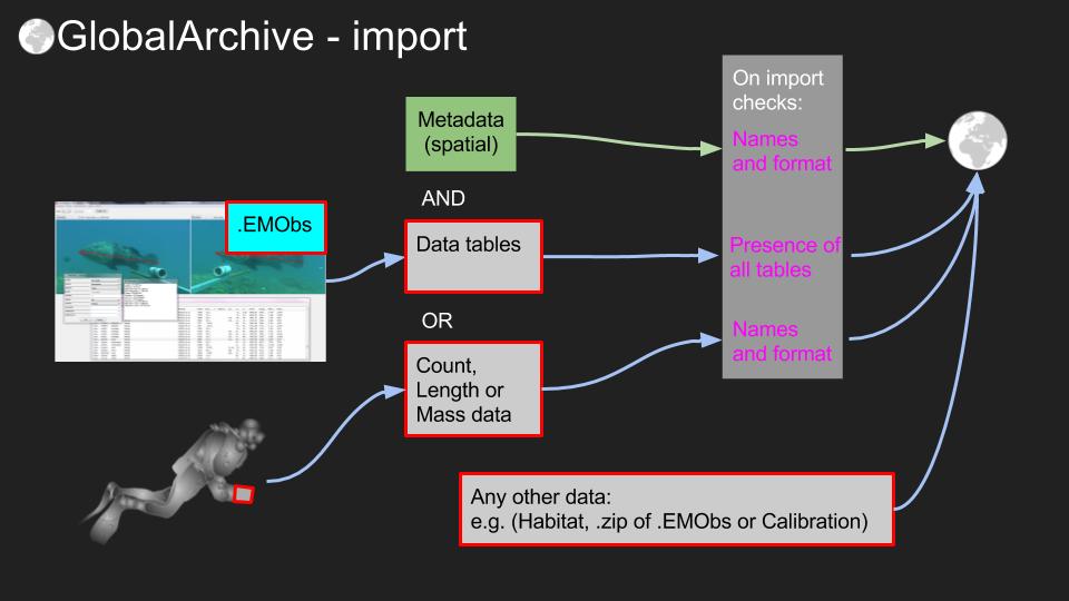 Figure 1. Overview of GlobalArchive import workflow
Eventmeasure observation files (.EMObs)
GlobalArchive provides a complete archive of all the information held with an EventMeasure annotation file (.EMObs). However, GlobalArchive is NOT a video repository and therefore such annotation files remain the “true” copy of the data and any corrections must be made in the annotation file and then re-imported to GlobalArchive. Please look after your annotation files!
If you have used EventMeasure software to annotate your samples but have made “corrections” on exported data (e.g. in Excel), this “corrected” data is now the “true” copy of the data and you should import your data as generic annotation files (e.g. count, length and mass data).